
Ireland
geography
history
geography
culture
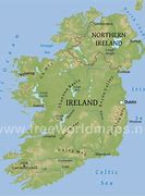
Ireland is an island in Northwestern
Europe in the north Atlantic Ocean. The island lies on
the European continental shelf, part of the Eurasian
Plate. The island's main geographical features include
low central plains surrounded by coastal mountains. The
highest peak is Carrauntoohil , which is 1,039 meters
(3,409 ft) above sea level. The western coastline
is rugged, with many islands, peninsulas, headlands and
bays. The island is bisected by the River Shannon, which
at 360.5 km (224 mi) with a 102.1 km (63 mi) estuary is
the longest river in Ireland and flows south from County
Cavan in Ulster to meet the Atlantic just south of
Limerick. There are a number of sizeable lakes along
Ireland's rivers, of which Lough Neagh is the largest.
Politically, the island consists of the Republic of
Ireland, with jurisdiction over about five-sixths of the
island, and Northern Ireland, a constituent country of
the United Kingdom, with jurisdiction over the remaining
sixth. Located west of the island of Great Britain, it
is located at approximately 53°N 8°WCoordinates: 53°N
8°W. It has a total area of 84,421 km2 (32,595 sq mi).
It is separated from Great Britain by the Irish Sea and
from mainland Europe by the Celtic Sea. Ireland forms
the second largest landmass in the North-West European
Archipelago, together with nearby islands including
Great Britain and the Isle of Man, known in the United
Kingdom as the British Isles.
